 |
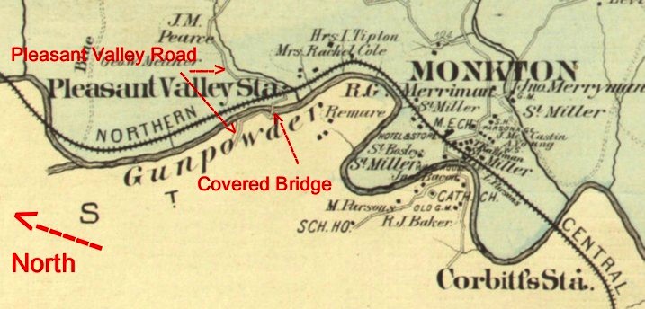
| 1877 Hopkins Map showing Pleasant Valley Station and Road and the bridge crossing. |
| Home | Existing Covered Bridges | Bygone Covered Bridges | Romantic Shelters | About Covered Bridges | Trusses | News | Links |
| COUNTY | WORLD GUIDE # | CROSSES | TRUSS | SPANS | LENGTH | BUILT | GONE |
| Baltimore | MD-03-35x | Gunpowder Falls | Unk | Unk | Unk | 1856 | c1900 |
Along the North Central Railway in the mid-1800s, about a mile north of Monkton, existed a railroad station called Pleasant Valley Station. A new road constructed west of the Gunpowder Falls provided travel for the community to get from Hereford to the railroad station but access was still difficult because Pleasant Valley Station was on the east side of Gunpowder Falls. An article in The Baltimore Sun on June 21, 1856 appropriated funds for building the bridge.
The county commissioners at their last session appropriated $1,600 for a covered bridge to be erected on the Gunpowder, between the 7th and 10th districts, at the point where the new road from Hereford via Pleasant Valley to the Black Horse in Harford county, crosses the railroad.
A follow up article on August 30, 1856 announced the awarding of the contract for building the bridge.
The contract for building the new county bridge over the Gunpowder at Pleasant Valley Road, above Monkton, has been awarded to Mr. Finley, of York, Pa. The price is $1,924, and the work is to be completed by the 1st of November next. It is said it will be a great convenience to that section of country, on both sides of the falls.
An 1877 Hopkins Atlas of Baltimore County shows Pleasant Valley Road and a bridge crossing to Pleasant Valley Station. An 1898 G. W. Bromley map also shows the road and crossing.
|
|
| 1877 Hopkins Map showing Pleasant Valley Station and Road and the bridge crossing. |
Unfortunately, the railroad and its station and the town declined in the late 1890s. Today, the North Central Railway is a popular hike and bike trail. A marker where the Pleasant Valley Station was once located reads, in part, as follows:
Pleasant Valley, roughly half a mile north of Monkton, was a 19th Century railroad settlement, built around mining operations. The settlement is mentioned by name in Civil War records of 1864. It is shown in the 1877 Hopkins Atlas, which indicates buildings, a bridge over the Gunpowder Falls, and a road leading west to Hereford.
The village was established to mine ore and soapstone. The iron ore deposits, like others along the railroad as such points as Glencoe, Padonia, and Lutherville, were worked in the early 1860s because of the proximity to the Ashland Iron Furnace. By 1864 this furnace had changed over to anthracite fuel because of the easy access to coal transported by the Northern Central Railroad and could produce more pig iron, requiring new sources of ore. Pleasant Valley soapstone was used in minor quantities by the mills, foundries, and other industries along the railroad.
By the late 1870s Pleasant Valley had become a compact village containing a railroad station, small houses, a tavern, and a hotel known as the "Rat Trap." The town was dropped from the train schedules in the 1890s and declined rapidly; by the early 1900s Pleasant Valley, the bridge, and Hereford road [aka Pleasant Valley road] had disappeared from official maps. The iron ore and soapstone veins had depleted, and their markets also disappeared.
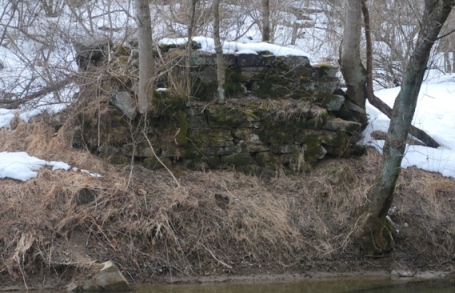
Today Pleasant Valley exists only as a few crumbling remains which can be seen from the NCR Trail. The foundation of the "Rat Trap" hotel, along with a few iron headboards, other stone foundations, bridge abutments and a spring head are all that remain.
 |
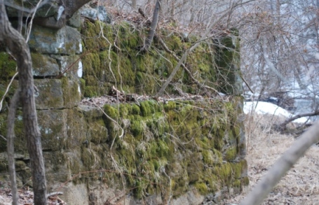 |
| Pleasant Valley Covered Bridge west side abutment. View is looking west from east side abutment on east side of Gunpowder Falls. Taken March 8, 2014. | Pleasant Valley Covered Bridge east side abutment. View is looking south from the nw corner of the east side abutment on east side of Gunpowder Falls. Taken March 8, 2014. |