Home Existing Covered Bridges Bygone Covered Bridges Romantic Shelters About Covered Bridges Trusses News Links

Covered Bridge at Point of Rocks

COUNTY WORLD GUIDE # CROSSES TRUSS SPANS LENGTH BUILT GONE
Frederick & Loudoun (VA) MD-10-11x & VA-53-02x Potomac River Unk 9 Approx 1,056' c1850s 1861
In the 1850s, The Potomac Furnace Company built a narrow covered bridge across the Potomac River to transport its pig iron to the Chesapeake & Ohio Canal and Baltimore & Ohio Railroad from the shores of Virginia to the Maryland side. It also used the railroad for shipments. Before the addition of the canal and railroad, the company, which had been in operation since the late 1700s, shipped their iron by boat using the skirting canals and falls along the Potomac. Unfortunately, the Covered Bridge at Point of Rocks was destroyed by the Confederate Army in 1861 when they went on a rampage destroying all bridges along the Potomac River and C&O Canal.¹
The bridge is also known as Leesburg Bridge. Once entering Virginia, the turnpike road was a direct southern route to the major town of Leesburg, Virginia. Some accounts report the bridge as over 3,500 feet long. The Potomac is no wider than a quarter of a mile at Point of Rocks, making the bridge a maximum of 1,320 feet. More than likely, the bridge crossed the river at an area about .20 mile wide or 1,056 feet.

¹Mike High The C&O Canal Companion (The Johns Hopkins University Press, Baltimore, MD: 2000), p.152.

Covered Bridge at Point of Rocks
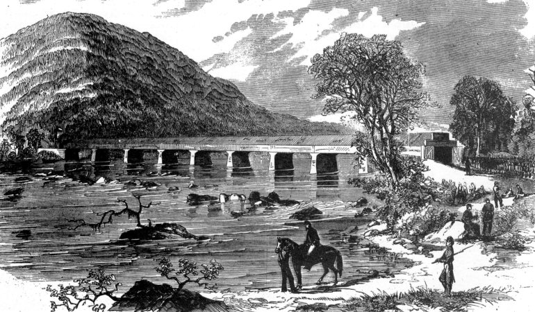
Illustration from Harper's Weekly, June 29, 1861. A brief description of the illustration from the same issue: "Leesburg bridge crosses the Potomac 13 miles below Harpers Ferry (at Point of Rocks), connecting Maryland with Loudoun County, Virginia, and is distant about 20 miles from the town of Leesburg. The river at this point is a quarter of a mile wide and flows over a very rocky bed. The high land seen on the Virginia side is Bull Run Mountain from the top of which a splendid view of the surrounding country is obtained. This position is at present held by about 2,000 Secessional troops, encamped on the Virginia side, with strong pickets thrown out for some distance along the Maryland shore."
(10-5-2015) Walker Smith, formerly of Doubs, MD, contacted us to let us know the writer for the caption of the Point of Rocks Bridge was incorrect stating the bridge was 20 miles from Leesburg. It is 12.4 miles. Also, the writer indicates the mountain range is Bull Run Mountain but he should have said Furnace Mountain.


Back to Bygone Covered Bridges

Maryland Covered Bridges
Email me: mdcoveredbridges@comcast.net