Home Existing Covered Bridges Bygone Covered Bridges Romantic Shelters About Covered Bridges Trusses News Links

Point of Rocks over Canal or Canal Road Covered Bridge

COUNTY WORLD GUIDE # CROSSES TRUSS SPANS LENGTH BUILT GONE
Frededick MD-10-08x Chesapeake & Ohio Canal Burr 2 Unk Unk Unk
Based on information supplied to us by some very knowledgeable persons about the Chesapeake & Ohio Canal, we have determined that this bridge was NOT a covered bridge. The photo shown below is that of the Monocacy Road Bridge that was burned during the Civil War.
The caption on the original photo shown below probably led to a lot of confusion about the bridge. Various covered bridge societies in the 1960s reported the bridge as a bygone Maryland Covered Bridge in their publications. Also, the book by Edwin Bearss, The Bridges of The C&O Canal, refers to the bridge as a permanent bridge. The term permanent bridge was most widely used when referencing a covered bridge. Adding to the confusion is that Wernwag built the original bridge in the 1830s. Wernwag was a famous covered bridge builder and did not dabble much in bridge building other than covered bridges.
It is understandable why covered bridge enthusiasts and historians back in the 1960s would have determined the Point of Rocks Canal Bridge was a covered bridge, but we firmly believe that the evidence we have received from our sources are correct when informing us the bridge was never a covered bridge. The bridge was once a pivot bridge. It then was rebuilt as a permanent bridge, a term used by the C & O Canal engineers to refer to a fixed deck bridge, or one that does not pivot.
We are thankful to Karen Gray of Hagerstown, Md and Pepper Scotto, Point of Rocks Historical Society, for taking the time to research the Point of Rocks Canal Bridge information.
The information shown below for the Point of Rocks Canal Bridge is the original writeup before finding out the bridge was NOT a covered structure. We did not change this information so readers may see the original documentation.
Canal Road or Point of Rocks Over the Canal Covered Bridge crossed the Chesapeake & Ohio Canal in Frederick County at an area previously known as Johnson's Point. In the 1830s, Lewis Wernwag built a pivot bridge at this canal location. It was rebuilt as a permanent bridge in 1844 and again in 1852. The bridge was used to provide access for traffic to reach the highway bridge across the Potomac River. Six floods of the Potomac River from 1896 to 1942 covered the Chesapeake & Ohio Canal towpath. The worst was 1936, reaching 17 feet above the towpath level. Only the center pier and abutments of the old covered bridge remain today.¹
Another source provides details of the pivot bridge and permanent bridge over the canal.²
A pivot bridge was constructed across the canal at Point of Rocks in 1834. A.J. Douglas supplied the stone and did the masonry, while Lewis Wernwag furnished the timber and built the bridge.
Captain William G. McNeill on December 1, 1833 reported that the bridge was nearly finished. He was impressed with the pivot bridges, because he foresaw that they would enable the Company to do away with the permanent bridges, "which constitute just a source of annoyance on canals generally." The under part of this bridge was 11 feet above the water's surface, and the pivot rested on a (center) square pier 15 feet in thickness, leaving a breadth of canal 22 1/2 feet on each side of it.
Superintendent Elgin on the last day of 1844 reported that there was "need of a great quantity of lumber on this division of various needed repairs." One of the projects requiring attention was the "renewal of the bridge at Point of Rocks." To repair the structure he needed 1,680 feet of lumber at 1 1/2 cents per lineal foot.
The bridge was rebuilt as a permanent structure. Apparently, the bridge had insufficient clearance, because W.R.S. Ward wrote on March 17, 1852, that many boatmen had complained that the bridge across the canal at Point of Rocks was so low it endangered their boats. That very day one of Ward's vessels had tied up at Georgetown, and the captain had protested that he was compelled to tie-up and take aboard stone, before he could pass under the bridge. Even so, his vessel had been "badly raked." The bridge was accordingly raised so that there would be a clearance of 17 feet.
Although undocumented, the double lane, two-span covered bridge over the canal is likely the permanent one built in 1852 and then destroyed in the flood of 1936.

UPDATED: 06/08/2013, removing this bridge as an authentic bygone covered bridge.

UPDATED: 12/01/2008, for conflict/confusion about same photo shown for Monocacy bridge and Point of Rocks over Canal bridge.

¹ Thomas F. Hahn, Towpath Guide to The C & O Canal, Georgetown (Tidewater) to Cumberland. (American Canal & Transportation Center: 1996), p.84.

² Edwin Bearss, The Bridges of the C&O Canal. (Denver Service Center; National Park Service, January, 1968), p. 147.

Point of Rocks over C&O Canal or Canal Road Covered Bridge
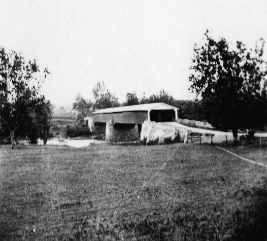
Point of Rocks Covered Bridge over C&O Canal or Canal Road Covered Bridge. This original photo, believed to be from about 1935, has typewritten at the bottom "Between Point of Rocks & Potomac R. Chesapeake & Ohio, Maryland." The quality of the photo is excellent and it does not appear to be a "picture of a picture." This bridge photo is also shown in The Baltimore and Ohio in the Civil War by Festus P. Summers as the bridge over the Monocacy River that was destroyed in the Civil War in 1864. The photo was a part of the Baltimore & Ohio Railroad Museum collection.